LC 00271: verschil tussen versies
Geen bewerkingssamenvatting |
Geen bewerkingssamenvatting |
||
| Regel 9: | Regel 9: | ||
''Type of area (rural or urban):'' a lot of residential area or urbanised zones within rural area, | ''Type of area (rural or urban):'' a lot of residential area or urbanised zones within rural area, | ||
''Relevant characteristics of the water system (main water bodies):'' the area lies 8 to 40 m above sea level and the main water body is the Dender river ( | ''Relevant characteristics of the water system (main water bodies):'' the area lies 8 to 40 m above sea level and the main water body is the Dender river ({{Cite|resource=Bestand:6449.7455.2 24 6 2019.pdf|name=Vlaams Milieumaatschappij|dialog=process-file-dialog}}, 2016). | ||
[[Bestand:Denderleeuw map.png|gecentreerd|miniatuur]] | [[Bestand:Denderleeuw map.png|gecentreerd|miniatuur]] | ||
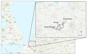
Figure 1: Map featuring the location of the FRAMES Belgian pilot areas, one of which is Denderleeuw. | Figure 1: Map featuring the location of the FRAMES Belgian pilot areas, one of which is Denderleeuw. | ||
Versie van 25 jun 2019 09:57
Area description
Denderleeuw lies in the Belgian province East Flanders.
The size of the pilot area is 13,77 km2. The majority of the area is residential, or urbanized within a rural area, but there are also industrial- and retail areas, farmlands, railways and roads.
Number of inhabitants: total of 20,086 inhabitants
Type of area (rural or urban): a lot of residential area or urbanised zones within rural area,
Relevant characteristics of the water system (main water bodies): the area lies 8 to 40 m above sea level and the main water body is the Dender river (Vlaams Milieumaatschappij, 2016).
Figure 1: Map featuring the location of the FRAMES Belgian pilot areas, one of which is Denderleeuw.
Referenties
- Evaluatie inventarisatie overstromingen november 2010 Denderbekken. Integraal Waterbeleid. Bekken van de Dender. Hoofdstuk 2.3. Bekkenvoortgangsrapport 2010. Denderbekken, Anoniem, Commissie Integraal Waterbeleid, 1 januari 2011.
- Flood resilience: a co-evolutionary approach : residents, spatial developments and flood risk management in the Dender Basin, Tempels, B., 5 december 2016.
- Stroomgebiedbeheerplan voor de Schelde 2016-2021. Bekkenspecifiek deel Denderbekken, Vlaamse Milieumaatschappij, 1 januari 2016.

