LC 00013: verschil tussen versies
(Nieuwe pagina aangemaakt met ' {{Light Context |Supercontext=FR PLT PR 00001 |Topcontext=PR 00069 |Toppage=Other |Sequence number=1 |Context type=Situation |Heading=Pilot description |Show refer...') |
Geen bewerkingssamenvatting |
||
| (Een tussenliggende versie door dezelfde gebruiker niet weergegeven) | |||
| Regel 1: | Regel 1: | ||
=== Area description === | |||
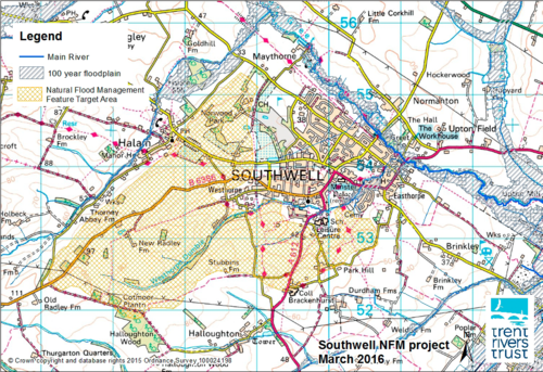
Southwell is a small rural landlocked market town in the East Midlands county of Nottinghamshire. The area surrounding the town is predominately arable farming with a little pastoral farming for cattle and sheep and a number of fields used for equine grazing, particularly those attached to Nottingham Trent University’s Equine School. | |||
[[Bestand:Map Southwell.png|gecentreerd|miniatuur|500x500px]] | |||
''Size of the pilot area'': The rural and urban catchment area surrounding the small market town of Southwell in Nottinghamshire is 6 km<sup>2</sup> (interview with pilot manager, 2019). | |||
''Number of inhabitants'': Approx. 7000 residents within the town and immediate surrounding countryside within the catchment area. (interview pilot manager, 2018). The number of people targeted required for the project is 500 (interview pilot manager, 2019) | |||
''Relevant characteristics of the water system'': Potwell Dyke and River Greet are tributaries of Trent River (interview pilot manager, 2019). | |||
=== Flood risks === | |||
Southwell itself sits within a ‘basin’ of these field, therefore when rainfall is particularly heavy or there is a period of flash flooding, the surface water runs off the hills and roads into the bottom of the basin, overwhelming the drainage system and creating pockets of flooding. This excess run-off and pockets of flooding create problems such as cutting off significant roads, property flooding and general disruption of peoples’ lives. | |||
{{Light Context | {{Light Context | ||
|Supercontext=FR PLT PR 00001 | |Supercontext=FR PLT PR 00001 | ||
Huidige versie van 24 sep 2019 om 08:43
Area description
Southwell is a small rural landlocked market town in the East Midlands county of Nottinghamshire. The area surrounding the town is predominately arable farming with a little pastoral farming for cattle and sheep and a number of fields used for equine grazing, particularly those attached to Nottingham Trent University’s Equine School.
Size of the pilot area: The rural and urban catchment area surrounding the small market town of Southwell in Nottinghamshire is 6 km2 (interview with pilot manager, 2019).
Number of inhabitants: Approx. 7000 residents within the town and immediate surrounding countryside within the catchment area. (interview pilot manager, 2018). The number of people targeted required for the project is 500 (interview pilot manager, 2019)
Relevant characteristics of the water system: Potwell Dyke and River Greet are tributaries of Trent River (interview pilot manager, 2019).
Flood risks
Southwell itself sits within a ‘basin’ of these field, therefore when rainfall is particularly heavy or there is a period of flash flooding, the surface water runs off the hills and roads into the bottom of the basin, overwhelming the drainage system and creating pockets of flooding. This excess run-off and pockets of flooding create problems such as cutting off significant roads, property flooding and general disruption of peoples’ lives.
Hier wordt aan gewerkt of naar verwezen door: Layer 1- Flood protection

