LC 00339: verschil tussen versies
(Nieuwe pagina aangemaakt met ' {{Light Context |Supercontext=FR PLT PR 00007 |Topcontext=PR 00069 |Toppage=Other |Sequence number=1 |Context type=Situation |Heading=Pilot description |Show refer...') |
Geen bewerkingssamenvatting |
||
| (Een tussenliggende versie door dezelfde gebruiker niet weergegeven) | |||
| Regel 1: | Regel 1: | ||
=== Area description === | |||
''Size of the pilot area'': approximately 3 km<sup>2</sup> | |||
''Number of inhabitants'': approximately 550 households | |||
[[Bestand:Map Roskilde.png|gecentreerd|miniatuur|400x400px]] | |||
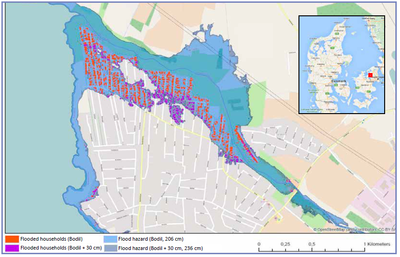
''Figure 1. Flood Hazard in Jyllinge Nordmark, Roskilde during the storm surge Bodil, 5th - 7th Dec 2013 ({{Cite|resource=Bestand:Frames Pilotbook mei19.pdf|name=Pilotbook, 2019|dialog=process-file-dialog}})'' | |||
''Relevant characteristics of the water system (main water bodies):'' Jyllinge Nordmark is a village located in Roskilde Municipality. Jyllinge Nordmark is situated in a low-lying area. New settlements are no longer occurring in the pilot area but existing settlement are not located optimal in regards to risk of flooding. Since 1990, the area has gradually been transformed into year-round housing and in Jyllinge Nordmark there are currently registered approximately 1740 year-round houses and almost 240 holiday homes. The remaining cottages are constantly being converted into year-round housing, and this development is expected to continue ({{Cite|resource=Bestand:LP668 Jyllinge Nordmark FORSLAG.pdf|name=Roskillde Kommune, 2017|dialog=process-file-dialog}}). | |||
=== Flood risks === | |||
The municipality of Roskilde town is located at the mouth of the Roskilde Fjord as part of the North Sea. Roskilde Fjord separates Hornsherred and North Zealand. At the south-east coast of the fjord is the town of Roskilde. Frederikssund and Jyllinge are larger showers along the eastern coast in the fjord. Jyllinge Nordmark where Værebro Å runs through the area has been heavily influenced by floods in recent years. The most recent major flood occurred on 6th December 2013, caused by the storm "Bodil", where the water level in Holbæk harbor was measured at 1.84 and 1.97 in Roskilde Harbor - both measured in DVR90. Early January 2019, there were several minor incidents with water levels of about 1.25 meters above daily water in the fjords ({{Cite|resource=Resource Hyperlink 00608|name=North Sea Region, 2019|dialog=process-linkwebsite-dialog}}). | |||
Roskilde municipality is in the process of establishing a dike. Since the area is subject to NATURA 2000 regulation, it has proved difficult to establish a dike ({{Cite|resource=Bestand:LP668 Jyllinge Nordmark FORSLAG.pdf|name=Roskillde Kommune, 2017|dialog=process-file-dialog}}). | |||
{{Light Context | {{Light Context | ||
|Supercontext=FR PLT PR 00007 | |Supercontext=FR PLT PR 00007 | ||
Huidige versie van 30 okt 2019 om 14:05
Area description
Size of the pilot area: approximately 3 km2
Number of inhabitants: approximately 550 households
Figure 1. Flood Hazard in Jyllinge Nordmark, Roskilde during the storm surge Bodil, 5th - 7th Dec 2013 (Pilotbook, 2019)
Relevant characteristics of the water system (main water bodies): Jyllinge Nordmark is a village located in Roskilde Municipality. Jyllinge Nordmark is situated in a low-lying area. New settlements are no longer occurring in the pilot area but existing settlement are not located optimal in regards to risk of flooding. Since 1990, the area has gradually been transformed into year-round housing and in Jyllinge Nordmark there are currently registered approximately 1740 year-round houses and almost 240 holiday homes. The remaining cottages are constantly being converted into year-round housing, and this development is expected to continue (Roskillde Kommune, 2017).
Flood risks
The municipality of Roskilde town is located at the mouth of the Roskilde Fjord as part of the North Sea. Roskilde Fjord separates Hornsherred and North Zealand. At the south-east coast of the fjord is the town of Roskilde. Frederikssund and Jyllinge are larger showers along the eastern coast in the fjord. Jyllinge Nordmark where Værebro Å runs through the area has been heavily influenced by floods in recent years. The most recent major flood occurred on 6th December 2013, caused by the storm "Bodil", where the water level in Holbæk harbor was measured at 1.84 and 1.97 in Roskilde Harbor - both measured in DVR90. Early January 2019, there were several minor incidents with water levels of about 1.25 meters above daily water in the fjords (North Sea Region, 2019).
Roskilde municipality is in the process of establishing a dike. Since the area is subject to NATURA 2000 regulation, it has proved difficult to establish a dike (Roskillde Kommune, 2017).
Referenties
- FRAMES pilotbook 2019, FRAMES, FRAMES, 1 mei 2019.
- The Isefjord/Holbaekfjord Estuary, North Sea Region, North Sea Region, 30 oktober 2109.
- Jyllinge Nordmark, Lokalplan 668, Roskillde Kommune, Roskillde Kommune, 23 oktober 2017.

