LC 00031: verschil tussen versies
Geen bewerkingssamenvatting |
Geen bewerkingssamenvatting |
||
| (3 tussenliggende versies door dezelfde gebruiker niet weergegeven) | |||
| Regel 1: | Regel 1: | ||
== Area description == | == Area description == | ||
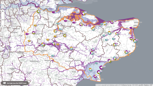
[[Bestand:Map Kent.png | [[Bestand:Map Kent.png|miniatuur|Map of pilot area: flood risk to health and social care properties in Kent.|gecentreerd|500x500px]] | ||
''Size of the pilot area'': 2200 km<sup>2</sup> and 563 km<sup>2</sup> of coastline ({{Cite|resource=Resource Hyperlink 00525|name=gov.uk, 2019|dialog=process-linkwebsite-dialog}}) | |||
''Number of inhabitants'': 1.55 million, the largest population of all English counties ({{Cite|resource=Resource Hyperlink 00525|name=gov.uk, 2019|dialog=process-linkwebsite-dialog}}) | |||
''Relevant characteristics of the water system'': | |||
The landscape of Kent is defined by its river systems and geography. The largest catchment in Kent, the Medway catchment, covers 2,409 km<sup>2</sup> comprising some 25% of the area of the County. The River Medway flows for 113 km from just inside the West Sussex border to the point where it enters the Thames Estuary in north Kent. The River Medway is tidal downstream of Allington Lock at Maidstone. Tributaries of the Medway include The Rivers Eden, Bourne, Teise, Beult, Sherway and Len, along with the Shaw and Loose Streams. | |||
The second largest catchment in Kent is that of the River Stour, fed by the East and Little Stour, the rivers Nailbourne, Wingham and Wantsum and the Aylesford, Brook, Kennington and North Streams. The major towns of Ashford and Canterbury have grown up on the banks of the River Stour. The river is tidal downstream of Fordwich. | |||
Other Kent rivers include the River Darent which rises at Westerham and Limpsfield Chart and joins the River Cray at Dartford Marshes before flowing into the Thames at Dartford Creek, the River Fleet which rises at Springhead Nursery and joins the River Thames at Northfleet, the River Dour which flows from Temple Ewell to the sea at Dover and the River Rother which forms part of the geographical boundary between the administrative counties of Kent and East Sussex (Kent County Council, July 2017). | |||
== Flood risks == | |||
Fluvial, pluvial, surface water and tidal flood risk are all present in Kent, and some flooding occurs regularly around the county. The most recent floods are listed below: | |||
{| class="wikitable" | |||
|'''Date''' | |||
|'''Type''' | |||
|'''People affected [number]''' | |||
|'''Damage [in Euro / GBP]''' | |||
|- | |||
|11 June 2019 | |||
|Pluvial Flooding | |||
|170+ houses | |||
|Unknown at present | |||
|- | |||
|29 May 2018 | |||
|Pluvial Flooding | |||
|2 | |||
|£200 (TBC) | |||
|- | |||
|29 April 2018 | |||
|Pluvial Flooding | |||
|6 | |||
|£1163.36 (TBC) | |||
|- | |||
|January 2018 | |||
|Pluvial | |||
|1 | |||
|£2000 (TBC) | |||
|} | |||
For more on flood risks in this area, please visit {{External link|resource=Resource Hyperlink 00526|name=https://www.gov.uk/check-flood-risk|dialog=process-linkwebsite-dialog}}. | |||
{{Light Context | {{Light Context | ||
Huidige versie van 19 feb 2020 om 09:52
Area description
Size of the pilot area: 2200 km2 and 563 km2 of coastline (gov.uk, 2019)
Number of inhabitants: 1.55 million, the largest population of all English counties (gov.uk, 2019)
Relevant characteristics of the water system:
The landscape of Kent is defined by its river systems and geography. The largest catchment in Kent, the Medway catchment, covers 2,409 km2 comprising some 25% of the area of the County. The River Medway flows for 113 km from just inside the West Sussex border to the point where it enters the Thames Estuary in north Kent. The River Medway is tidal downstream of Allington Lock at Maidstone. Tributaries of the Medway include The Rivers Eden, Bourne, Teise, Beult, Sherway and Len, along with the Shaw and Loose Streams.
The second largest catchment in Kent is that of the River Stour, fed by the East and Little Stour, the rivers Nailbourne, Wingham and Wantsum and the Aylesford, Brook, Kennington and North Streams. The major towns of Ashford and Canterbury have grown up on the banks of the River Stour. The river is tidal downstream of Fordwich.
Other Kent rivers include the River Darent which rises at Westerham and Limpsfield Chart and joins the River Cray at Dartford Marshes before flowing into the Thames at Dartford Creek, the River Fleet which rises at Springhead Nursery and joins the River Thames at Northfleet, the River Dour which flows from Temple Ewell to the sea at Dover and the River Rother which forms part of the geographical boundary between the administrative counties of Kent and East Sussex (Kent County Council, July 2017).
Flood risks
Fluvial, pluvial, surface water and tidal flood risk are all present in Kent, and some flooding occurs regularly around the county. The most recent floods are listed below:
| Date | Type | People affected [number] | Damage [in Euro / GBP] |
| 11 June 2019 | Pluvial Flooding | 170+ houses | Unknown at present |
| 29 May 2018 | Pluvial Flooding | 2 | £200 (TBC) |
| 29 April 2018 | Pluvial Flooding | 6 | £1163.36 (TBC) |
| January 2018 | Pluvial | 1 | £2000 (TBC) |
For more on flood risks in this area, please visit https://www.gov.uk/check-flood-risk.
Referenties
- Website with all UK government departments and many other agencies and public bodies, Government of the UK, 6 september 2019.
Hier wordt aan gewerkt of naar verwezen door: Layer 1- Flood protection, Layer 1- Flood protection, Project outcomes and beyond

