LC 00271: verschil tussen versies
Geen bewerkingssamenvatting |
Geen bewerkingssamenvatting |
||
| Regel 15: | Regel 15: | ||
Flood risks come from the Dender River; the risk probability is considered medium | Flood risks come from the Dender River; the risk probability is considered medium | ||
* The Dender has naturally a quick hydrological response because the combination of a strong topography and the loam soils in the uphill zones ( | * The Dender has naturally a quick hydrological response because the combination of a strong topography and the loam soils in the uphill zones ({{Cite|resource=Bestand:6449.7455.2 24 6 2019.pdf|name=Vlaams Milieumaatschappij|dialog=process-file-dialog}}, 2016). In case of intense rainfall, the river response is relatively quickly, increasing its level. Furthermore, the Dender Basin has been subject to land sealing through urbanization enhancing this process. | ||
* The last flood of 2010 had a lot of impact and was identified as having a return period of 100 years. During these floods, an estimated 51 households were flooded (CIW, 2011). According to forecasts this could change into a 20 years return period by 2100 onwards. The total financial damage after the floods of 2010 was estimated at 180.000.000 EUR for the whole Dender catchment (Tempels, 2016). | * The last flood of 2010 had a lot of impact and was identified as having a return period of 100 years. During these floods, an estimated 51 households were flooded (CIW, 2011). According to forecasts this could change into a 20 years return period by 2100 onwards. The total financial damage after the floods of 2010 was estimated at 180.000.000 EUR for the whole Dender catchment ({{Cite|resource=Resource Hyperlink 00427|name=Tempels, 2016|dialog=process-linkwebsite-dialog}}). | ||
* Impacts: If a flooding occurs, the potential number of households affected would be 228 ({{Cite|resource=Resource Hyperlink 00427|name=Tempels, 2016|dialog=process-linkwebsite-dialog}}). | * Impacts: If a flooding occurs, the potential number of households affected would be 228 ({{Cite|resource=Resource Hyperlink 00427|name=Tempels, 2016|dialog=process-linkwebsite-dialog}}). | ||
{{Light Context | {{Light Context | ||
|Supercontext=FR PLT PR 00011 | |Supercontext=FR PLT PR 00011 | ||
Versie van 25 jun 2019 10:02
Area description
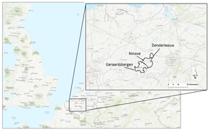
Denderleeuw lies in the Belgian province East Flanders.
The size of the pilot area is 13,77 km2. The majority of the area is residential, or urbanized within a rural area, but there are also industrial- and retail areas, farmlands, railways and roads.
Number of inhabitants: total of 20,086 inhabitants
Type of area (rural or urban): a lot of residential area or urbanised zones within rural area,
Relevant characteristics of the water system (main water bodies): the area lies 8 to 40 m above sea level and the main water body is the Dender river (Vlaams Milieumaatschappij, 2016).
Figure 1: Map featuring the location of the FRAMES Belgian pilot areas, one of which is Denderleeuw.
Flood risks
Flood risks come from the Dender River; the risk probability is considered medium
- The Dender has naturally a quick hydrological response because the combination of a strong topography and the loam soils in the uphill zones (Vlaams Milieumaatschappij, 2016). In case of intense rainfall, the river response is relatively quickly, increasing its level. Furthermore, the Dender Basin has been subject to land sealing through urbanization enhancing this process.
- The last flood of 2010 had a lot of impact and was identified as having a return period of 100 years. During these floods, an estimated 51 households were flooded (CIW, 2011). According to forecasts this could change into a 20 years return period by 2100 onwards. The total financial damage after the floods of 2010 was estimated at 180.000.000 EUR for the whole Dender catchment (Tempels, 2016).
- Impacts: If a flooding occurs, the potential number of households affected would be 228 (Tempels, 2016).
Referenties
- Evaluatie inventarisatie overstromingen november 2010 Denderbekken. Integraal Waterbeleid. Bekken van de Dender. Hoofdstuk 2.3. Bekkenvoortgangsrapport 2010. Denderbekken, Anoniem, Commissie Integraal Waterbeleid, 1 januari 2011.
- Flood resilience: a co-evolutionary approach : residents, spatial developments and flood risk management in the Dender Basin, Tempels, B., 5 december 2016.
- Stroomgebiedbeheerplan voor de Schelde 2016-2021. Bekkenspecifiek deel Denderbekken, Vlaamse Milieumaatschappij, 1 januari 2016.

