LC 00270: verschil tussen versies
Geen bewerkingssamenvatting |
Geen bewerkingssamenvatting |
||
| Regel 1: | Regel 1: | ||
== Area description == | |||
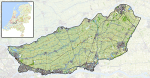
Alblasserwaard - Vijfheerenlanden is an area in the province of Zuid Holland and lies between the rivers the Lek, the Merwede, the Noordand the Linge. | |||
[[Bestand:Map Alblasserwaard - Vijfheerenland.png|gecentreerd|miniatuur]] | |||
''Number of inhabitants'': to be added | |||
''Relevant characteristics of the water system:'' The Alblasserwaard-Vijfheerenlanden tilts from east to west and is is two metres below sea level and during a flooding event the water level can rise up to 4 metres in relation to NAP (average sea level). | |||
{{Light Context | {{Light Context | ||
|Supercontext=FR PLT PR 00004 | |Supercontext=FR PLT PR 00004 | ||
Versie van 3 sep 2019 08:43
Area description
Alblasserwaard - Vijfheerenlanden is an area in the province of Zuid Holland and lies between the rivers the Lek, the Merwede, the Noordand the Linge.
Number of inhabitants: to be added
Relevant characteristics of the water system: The Alblasserwaard-Vijfheerenlanden tilts from east to west and is is two metres below sea level and during a flooding event the water level can rise up to 4 metres in relation to NAP (average sea level).
Referenties
- CBS, CBS, 1 januari 2020.
- Overstromingsrisico Alblasserwaard Vijfheerenlanden, Vergouwe et al., Rijkswaterstaat WVL, 1 mei 2014.
Hier wordt aan gewerkt of naar verwezen door: Layer 1- Flood protection

