PR 00274: verschil tussen versies
Geen bewerkingssamenvatting |
Geen bewerkingssamenvatting |
||
| Regel 1: | Regel 1: | ||
[[Bestand:DSS concept map placeholder.png|gecentreerd|miniatuur|700x700px]] | [[Bestand:DSS concept map placeholder.png|gecentreerd|miniatuur|700x700px]] | ||
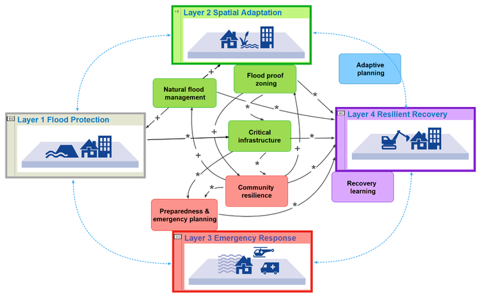
In this Decision Support System, we link the knowledge gained from the 16 pilot projects to the four layers of the MLS approach: | |||
* '''Layer 2, Spatial adaptation''': limits flood consequences (a) when applying spatial adaptation measures for vulnerable electricity grid assets | |||
* '''Layer 3, Emergency management''': supports preparedness and emergency planning by (a) raising flood risk awareness of about the vulnerability of critical infrastructure; (b) update local flood action plans including evacuation routes and risk communication strategies based on updated flood risk maps; (d) update asset management plans; | |||
* '''Layer 4, Resilient recovery''': when flood preparedness measures are taken, it leads to a better flood recovery for communities. | |||
By clicking on the boxes in the figure above, you can find out what kind of actions are linked to that specific layers, what the lessons learned for that layer are, and what kind of capacities are needed to implement the action. A list of tools used to implement the action are listed as well. | |||
{{Project config}} | {{Project config}} | ||
Versie van 6 apr 2020 09:47
In this Decision Support System, we link the knowledge gained from the 16 pilot projects to the four layers of the MLS approach:
- Layer 2, Spatial adaptation: limits flood consequences (a) when applying spatial adaptation measures for vulnerable electricity grid assets
- Layer 3, Emergency management: supports preparedness and emergency planning by (a) raising flood risk awareness of about the vulnerability of critical infrastructure; (b) update local flood action plans including evacuation routes and risk communication strategies based on updated flood risk maps; (d) update asset management plans;
- Layer 4, Resilient recovery: when flood preparedness measures are taken, it leads to a better flood recovery for communities.
By clicking on the boxes in the figure above, you can find out what kind of actions are linked to that specific layers, what the lessons learned for that layer are, and what kind of capacities are needed to implement the action. A list of tools used to implement the action are listed as well.

