LC 00153: verschil tussen versies
Geen bewerkingssamenvatting |
Geen bewerkingssamenvatting |
||
| Regel 1: | Regel 1: | ||
=== Area description === | |||
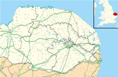
The scope location of the pilot project is north of Great Yarmouth, Gorleston and a village close by called Bradwell. It is a low lying area where Great Yarmouth and Gorleston are located below sea level. In terms of geography Great Yarmouth is formed by sand banks from the sea so it is not that old as Gorleston. | |||
[[Bestand:Map Norflock County.png|gecentreerd|miniatuur|400x400px]] | |||
''Size:'' the pilot area covers 10.075 km2 | |||
''Number of inhabitants'': 38.693 | |||
''Relevant characteristics of the water system'': the River Yare cuts off Great Yarmouth from other areas of the borough.The County borders the North Sea. | |||
=== Flood risks === | |||
{{Light Context | {{Light Context | ||
|Supercontext=FR PLT PR 00013 | |Supercontext=FR PLT PR 00013 | ||
Versie van 24 sep 2019 12:43
Area description
The scope location of the pilot project is north of Great Yarmouth, Gorleston and a village close by called Bradwell. It is a low lying area where Great Yarmouth and Gorleston are located below sea level. In terms of geography Great Yarmouth is formed by sand banks from the sea so it is not that old as Gorleston.
Size: the pilot area covers 10.075 km2
Number of inhabitants: 38.693
Relevant characteristics of the water system: the River Yare cuts off Great Yarmouth from other areas of the borough.The County borders the North Sea.
Flood risks
Hier wordt aan gewerkt of naar verwezen door: Layer 1- Flood protection

