Pilot description
Area description
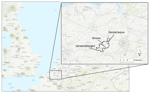
Denderleeuw lies in the Belgian province East Flanders.
The size of the pilot area is 13,77 km2. The majority of the area is residential, or urbanized within a rural area, but there are also industrial- and retail areas, farmlands, railways and roads.
Number of inhabitants: total of 20,086 inhabitants
Type of area (rural or urban): a lot of residential area or urbanised zones within rural area,
Relevant characteristics of the water system (main water bodies): the area lies 8 to 40 m above sea level and the main water body is the Dender river (Vlaams Milieumaatschappij, 2016).
Figure 1: Map featuring the location of the FRAMES Belgian pilot areas, one of which is Denderleeuw.
Referenties
- Evaluatie inventarisatie overstromingen november 2010 Denderbekken. Integraal Waterbeleid. Bekken van de Dender. Hoofdstuk 2.3. Bekkenvoortgangsrapport 2010. Denderbekken, Anoniem, Commissie Integraal Waterbeleid, 1 januari 2011.
- Flood resilience: a co-evolutionary approach : residents, spatial developments and flood risk management in the Dender Basin, Tempels, B., 5 december 2016.
- Stroomgebiedbeheerplan voor de Schelde 2016-2021. Bekkenspecifiek deel Denderbekken, Vlaamse Milieumaatschappij, 1 januari 2016.

