Geen bewerkingssamenvatting |
k (1 versie geïmporteerd: Zie Jira-task KP-222.) |
||
| (56 tussenliggende versies door 6 gebruikers niet weergegeven) | |||
| Regel 1: | Regel 1: | ||
<div id="emmskin-extra-row"> | <div id="emmskin-extra-row"> | ||
<h1 id="firstHeading" class="firstHeading page-title">FRAMES: Flood Resilient Areas by Multi-Layered Safety </h1> | <h1 id="firstHeading" class="firstHeading page-title">FRAMES: Flood Resilient Areas by Multi-Layered Safety </h1> | ||
</div><div id="emmskin-extra-row"> | |||
Floods are among the world’s most common and most devastating natural hazards and have affected millions of people in Europe since the beginning of this century. Changes in our climate are increasing the risk of river and coastal flooding because sea levels are rising and rainfall patterns are becoming more extreme. Increasing flood risks call for more innovative approaches to minimize the impacts of such events. Therefore, five countries bordering the North Sea Region, Denmark, Germany, the Netherlands, Belgium and the United Kingdom, have joint forces in the Interreg North Sea Region project FRAMES. | |||
</div> | </div> | ||
{{BB Query | |||
|pagenames=PR_00266,LC_00365,LC_00355,LC_00374,LC_00373,PR_00153,PR_00274,PR_00152,LC_00389 | |||
|formatter=FMT Card | |||
}} | |||
The results of FRAMES (2016-2020) are highly relevant for policymakers and practitioners working on flood risk management at the local, regional and national scale. By clicking on the blocks above, you will be able to download our final reports, policy recommendations and layman's report, discover the details of all the 16 pilot projects, access the Decision Support System, glossary and Toolkit, read our peer-reviewed articles and take a look a videos shot for FRAMES. | |||
''[Please note that formally, the project includes 15 pilot projects; the pilot areas Vejle and Assens were included in 1 pilot project. However, both had their own outcomes and learning process, we therefore have included both separately in the FRAMES wiki]'' | |||
==== FRAMES ==== | |||
[[Bestand:4layer_illustratie_totaal.jpg|rechts|kaderloos]] | |||
FRAMES stands for Flood Resilient Areas by Multi-layEred Safety. Traditionally, structural and static solutions were the preferred management option to defend against flooding. However, it is more and more recognized that protection alone will not be enough to make areas climate-resilient. It is also imperative to decrease the effects of flooding and look at spatial planning and disaster management as well. This so-called Multi-Layer Safety (MLS) approach is thus based on three layers: 1) protection, the primary dike system; 2) sustainable spatial planning that decreases the loss should a flood occur; and 3) disaster management, the organizational aspects related to a flood event. Our project added a fourth layer to this approach: 4) resilient recovery. Together, these four layers can be tailored to local areas in order to minimize flood damage. | |||
| | |||
<!-- tijdelijk om landen aan te maken | <!-- tijdelijk om landen aan te maken | ||
| Regel 44: | Regel 30: | ||
| Project[Show sources]=Nee | | Project[Show sources]=Nee | ||
}} | }} | ||
--> | -->The FRAMES-video below explains Multi-Layer Safety in 90 seconds: | ||
The FRAMES-video below explains Multi-Layer Safety in 90 seconds: | |||
| Regel 62: | Regel 42: | ||
| format=datatables | | format=datatables | ||
} | } | ||
-->{{ | -->{{BB Video|id=_AtYMXiFJ3g|type=YouTube|width=800|height=500}} | ||
{{BB Logos | |||
|heading={{int:EMM Text FRAMES Partners}} | |||
|summary= | |||
|images= | |||
logo-frames-ghent-university.png, | |||
logo-frames-hz.png, | |||
logo-frames-jade-hochschule-wilhelmshaven.png, | |||
logo-frames-kent-county-council.png, | |||
logo-frames-national-flood-forum.jpg, | |||
logo-frames-oowv.png, | |||
logo-frames-provincie-oost-vlaanderen.png , | |||
logo-frames-provincie-zeeland.png, | |||
logo-frames-veiligheidsregio-zeeland.png, | |||
logo-frames-provincie-zuid-holland.png, | |||
logo-frames-rijkswaterstaat-lnv.png, | |||
logo-frames-tees-rivers-trust.jpg, | |||
logo-frames-the-rivers-trust.jpg, | |||
logo-frames-trent-rivers-trust.jpg, | |||
logo-frames-universitat-oldenburg.png, | |||
logo-frames-south-east-rivers-trust.png, | |||
logo-frames-kystdirektoratet.png | |||
}} | |||
{{Project homepage config | {{Project homepage config | ||
| Project code=FRAMES | | Project code=FRAMES | ||
| Regel 75: | Regel 71: | ||
{{Project config}} | {{Project config}} | ||
{{Project | {{Project | ||
|Name=FRAMES - Flood Resilient Areas by Multi-Layered Safety | |||
|Supercontext=Resilient Deltas | |Supercontext=Resilient Deltas | ||
|Start date=2016/10/01 | |Start date=2016/10/01 | ||
|End date=2020/ | |End date=2020/07/31 | ||
|Summary=In FRAMES, we | |Summary=In FRAMES, we looked at how Multi-Layer Safety, or MLS, can improve the overall resilience of areas, communities and authorities in 16 pilot areas. Using a transnational learning evaluation approach, all pilots projects were evaluated and compared. Next to that, transnational focus groups were organized to evaluate and learn from transnational results. This learning process allowed us to generate new insights to support future decision making and show innovative solutions to improve society’s ability to cope with flooding. FRAMES ran from October 2016 till July 2020. | ||
|Show summary=Nee | |Show summary=Nee | ||
|Show extra=Ja | |||
|Show navigation tree=Nee | |Show navigation tree=Nee | ||
|Show new page button=Nee | |Show new page button=Nee | ||
| Regel 89: | Regel 85: | ||
|Is homepage=Ja | |Is homepage=Ja | ||
|Show edit button=Nee | |Show edit button=Nee | ||
|Show VE button= | |Show VE button=Nee | ||
|Show sidebar=Ja | |Show sidebar=Ja | ||
|Show category label=Nee | |Show category label=Nee | ||
|Show title=Nee | |Show title=Nee | ||
|Project type=Standaard | |||
|Create process and content pages=Nee | |Create process and content pages=Nee | ||
|Show info=Ja | |Show info=Ja | ||
}} | }} | ||
__NOTOC__ | |||
Huidige versie van 15 okt 2024 om 16:06
FRAMES: Flood Resilient Areas by Multi-Layered Safety
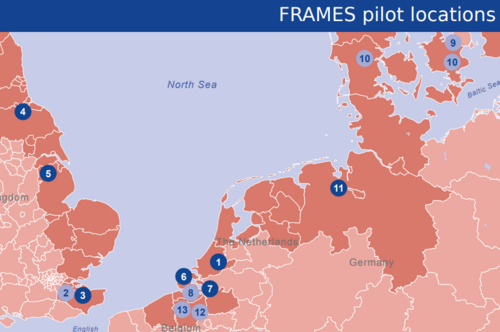
Floods are among the world’s most common and most devastating natural hazards and have affected millions of people in Europe since the beginning of this century. Changes in our climate are increasing the risk of river and coastal flooding because sea levels are rising and rainfall patterns are becoming more extreme. Increasing flood risks call for more innovative approaches to minimize the impacts of such events. Therefore, five countries bordering the North Sea Region, Denmark, Germany, the Netherlands, Belgium and the United Kingdom, have joint forces in the Interreg North Sea Region project FRAMES.
Pilots


Decision Support System


The results of FRAMES (2016-2020) are highly relevant for policymakers and practitioners working on flood risk management at the local, regional and national scale. By clicking on the blocks above, you will be able to download our final reports, policy recommendations and layman's report, discover the details of all the 16 pilot projects, access the Decision Support System, glossary and Toolkit, read our peer-reviewed articles and take a look a videos shot for FRAMES.
[Please note that formally, the project includes 15 pilot projects; the pilot areas Vejle and Assens were included in 1 pilot project. However, both had their own outcomes and learning process, we therefore have included both separately in the FRAMES wiki]
FRAMES

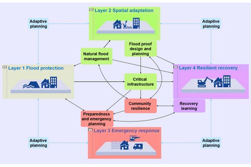
FRAMES stands for Flood Resilient Areas by Multi-layEred Safety. Traditionally, structural and static solutions were the preferred management option to defend against flooding. However, it is more and more recognized that protection alone will not be enough to make areas climate-resilient. It is also imperative to decrease the effects of flooding and look at spatial planning and disaster management as well. This so-called Multi-Layer Safety (MLS) approach is thus based on three layers: 1) protection, the primary dike system; 2) sustainable spatial planning that decreases the loss should a flood occur; and 3) disaster management, the organizational aspects related to a flood event. Our project added a fourth layer to this approach: 4) resilient recovery. Together, these four layers can be tailored to local areas in order to minimize flood damage.
The FRAMES-video below explains Multi-Layer Safety in 90 seconds: